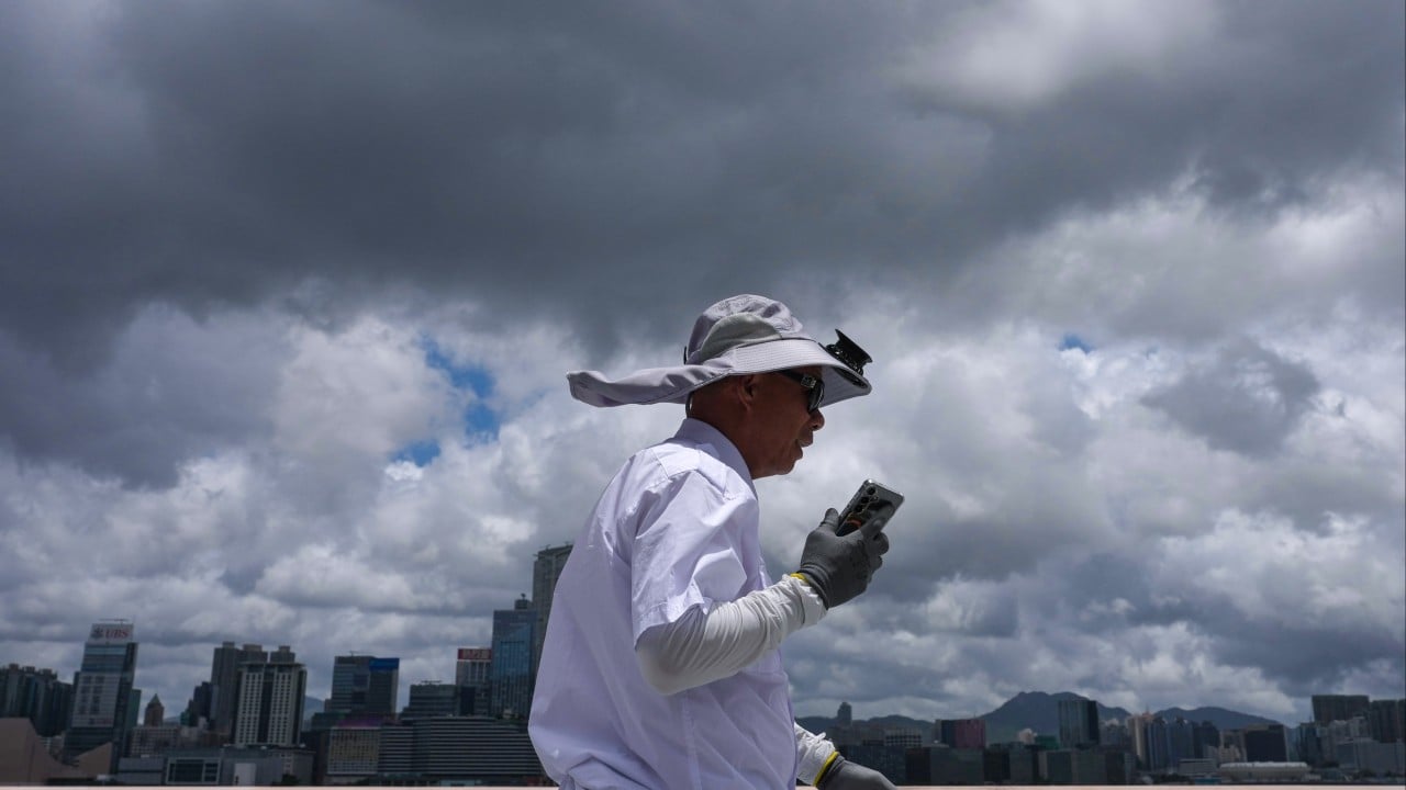
The air in Hong Kong before a storm does not blow; it weighs. It settles over the neon signage of Nathan Road and presses against the glass skyscrapers of Central like a damp wool blanket. On the radar screens at the Hong Kong Observatory, Tropical Storm Maysak is a swirling mass of bruised purples and angry reds, crawling its way across the South China Sea. But on the ground, the city is caught in a peculiar, high-stakes limbo.
The official announcement came down with the sterile precision typical of meteorological bureaus: the Standby Signal, No. 1, will remain in force until at least 6 p.m.
To an outsider, a T1 signal looks like nothing at all. The financial markets remain open. The double-decker buses still roar through the narrow corridors of Kowloon. The ferries still churn the green waters of Victoria Harbour. But to the seven million people who pack this vertical territory, that single digit is a psychological tripwire. It is the beginning of the great negotiation.
The Geometry of Suspense
Consider a hypothetical citizen. Let’s call her Mei-ling. She sits on the 24th floor of a mid-levels office tower, her eyes darting between an Excel spreadsheet and the tiny tropical cyclone tracking map bookmarked on her browser. For Mei-ling, and millions like her, Maysak is not just a meteorological event. It is a complex mathematical equation involving childcare logistics, grocery store supply chains, and the exact probability of getting sent home early from work.
Hong Kong operates on a rigid, deeply ingrained choreography when it comes to extreme weather. The signals are not mere warnings; they are legal mandates that alter the friction of daily life.
- Signal No. 1: A storm is within 800 kilometers. Watch the skies.
- Signal No. 3: Strong winds are arriving. The umbrellas begin to turn inside out.
- Signal No. 8: The city shuts down. Windows are taped. The streets go ghost-quiet.
By extending the T1 signal until at least the evening commute, the government effectively told the city to keep working, but to do so with one eye on the exit. It creates a distinct tension. It is the communal anxiety of a population waiting for the other shoe to drop, or in this case, for the wind to shift.
Walk down the wet alleyways of Mong Kok right now and you can see the preparations happening in near-silence. Shopkeepers are eyeing their canvas awnings. Fishmongers at the wet markets are adjusting their plastic tarps, calculating how much stock they can afford to lose if the sky opens up early. There is an unspoken expertise here, a generational muscle memory built from decades of surviving typhoons. Everyone knows the signs. The way the humidity clings to the skin like grease. The unnatural stillness of the harbor. The sudden, frantic flight of the city’s black kites circling high above the peak.
The Machine that Never Sleeps
The true marvel of this waiting period is how the city’s infrastructure handles the strain of uncertainty. The MTR, Hong Kong’s subterranean nervous system, operates with a rhythmic perfection that defies the gathering clouds. Trains slide into stations every two minutes, swallowing thousands of commuters who are checking their phones for the latest Observatory bulletins.
Behind the scenes, the stakes are staggering. Hong Kong is a city built on the concept of momentum. If the financial markets close early due to a higher signal, billions of dollars in volume hang in the balance. Shipping containers stacked five high at the Kwai Tsing Container Terminals must be lashed down with massive steel cables. Crane operators, working hundreds of feet in the air, must decide exactly when the gusts become too treacherous to continue moving the lifeblood of global trade.
Yet, the Observatory must balance this economic pressure against human safety. Call it too early, and you paralyze one of the world's most vital financial hubs for a storm that might ultimate veer toward Guangdong or Taiwan. Call it too late, and you trap millions of people in transit as gale-force winds slam into the coastline.
It is a terrifying tightrope walk. The decision to hold the T1 until 6 p.m. is a calculated gamble, a buffer designed to get the working population through the core of the business day before the real fury of Maysak arrives.
The Lessons of the Gray Sky
There is a profound vulnerability in watching a storm approach from a city made of glass. We like to believe our engineering has insulated us from the whims of the natural world. We build taller, we dig deeper, we reclaim land from the sea itself. But a tropical storm humbles the architecture. It turns the tallest towers into tuning forks that sway subtly in the wind, a terrifying but necessary design feature that keeps them from snapping.
For those who have lived through the destructive paths of past super typhoons, the current calm is not comforting. It feels like a deception. They remember the sound of shattering glass, the sight of ancient banyan trees ripped upward by their roots, and the brown floodwaters rushing through underground shopping malls.
Maysak may not become a monster. It might lose steam over the cooler waters closer to the coast, or it might change direction entirely. The current tracking maps show a slow, deliberate march toward the Pearl River Delta, a trajectory that keeps everyone guessing.
But as the clock ticks closer to 6 p.m., the atmosphere changes. The gray sky turns a bruised, twilight purple ahead of schedule. The first heavy drops of rain begin to splatter against the hot asphalt, evaporating into small plumes of steam. The waiting is almost over. The city takes a collective breath, tightens its grip on its umbrellas, and prepares for whatever comes next.