When a magnitude 7.7 earthquake tore through Panama's Herrera province, it did not take long for regional warning centers to light up. Within minutes, automated models flagged a potential basin-wide maritime hazard, throwing nine nations across Central and South America onto immediate tsunami alert. For a terrifying window on that October morning, coastlines from Colombia to Mexico braced for impact while seismologists scrambled to separate raw digital alarms from physical reality.
The epicenter struck inland near the community of Pitaloza Arriba at a shallow depth of roughly ten kilometers. Shallow ruptures of that magnitude carry an inherent destructive capacity because the energy has minimal distance to dissipate before reaching the surface. In Panama City, roughly two hundred kilometers away, the impact was immediate. High-rise office towers swayed violently, sending thousands of panicked office workers and residents spilling into the streets. Videos shared across social networks showed water sloshing out of rooftop swimming pools and bridges shuddering over the Panama Canal, though the vital shipping artery quickly resumed normal operations after initial safety sweeps. If you found value in this article, you might want to look at: this related article.
Yet the true panic extended far beyond the immediate zone of structural shaking. The Pacific Tsunami Warning Center issued broad advisories warning of possible hazardous waves along the shores of Panama, Colombia, Costa Rica, Ecuador, Peru, Nicaragua, Guatemala, El Salvador, and Mexico.
The Anatomy of a False Alarm
Why did a land-centered rupture trigger such an extensive maritime warning network? Modern seismic hazard protocols operate on strict worst-case assumptions during the opening minutes of a major event. When the United States Geological Survey initially pegged the magnitude at an alarming 8.0 before downwardly revising it to 7.6 and eventually settling at 7.7, automated algorithms factored in both the energy release and the shallow focal depth. For another look on this story, refer to the recent update from Reuters.
In subduction zones or major offshore faults, a shallow quake of that size frequently displaces the ocean floor, generating destructive displacement waves. However, the Azuero-Soná fault system behaves differently. Because the rupture occurred primarily on land within the Azuero Peninsula, the mechanical displacement required to push a massive volume of open ocean water across the basin was largely absent.
Seismic analysts face a permanent dilemma. Issue an alert too slowly, and coastal populations lose vital evacuation time. Issue it too broadly, and communities hundreds of miles away suffer economic disruption and unnecessary terror. Within hours of the Panama event, offshore deep-ocean pressure sensors and coastal tide gauges confirmed that the displacement vectors did not support a destructive basin-wide tsunami. The threat was canceled before afternoon, turning a catastrophic projection into a profound exercise in emergency logistics.
The Hidden Vulnerabilities on Land
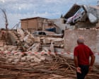
While the coastal tsunami alerts proved fleeting, the terrestrial damage was entirely tangible. In Herrera, Coclé, Los Santos, and Veraguas provinces, adobe structures, brick walls, and older residential properties bore the brunt of the ground acceleration. Local media and former officials shared images of collapsed roofs and fractured masonry, including structural failures at residential properties in Soná. At least twenty-seven people sustained injuries, mostly from falling debris and panic-induced accidents during evacuations.
More than eighty aftershocks rattled the region in the immediate aftermath, including a notable magnitude 5.8 tremor that kept traumatized residents sleeping outdoors. In towns like Isla Cañas, minor wind-driven or seismic surges did reach coastal doorsteps, reminding inhabitants that proximity to the Pacific leaves very little margin for error when tectonic plates shift beneath their feet.
Governments across Central America are now forced to re-evaluate urban preparedness. Panama City’s vertical boom over the past two decades has transformed the skyline into a forest of glass and steel. While modern engineered skyscrapers possess the flexible ductility required to survive heavy lateral shaking, secondary hazards—such as unsecured facade elements, interior stampedes, and communication grid overloads—remain persistent vulnerabilities.
The system worked precisely as engineered to prevent loss of life at sea, but the infrastructure on land continues to test the limits of public resilience.