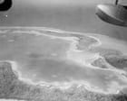
Paper fades. Silver tarnishes. Yet a stack of freshly unearthed historical photographs inside a museum archive can make a long-vanished strip of coral feel as immediate as the salt stinging your lips on a wind-whipped deck.
Salt. You taste it first when you look at an archival aerial plate of Nikumaroro, formerly Gardner Island, a razor-thin crescent of coral and scrub sitting in the remote Phoenix Islands of the central Pacific. You smell sun-baked limestone and damp copra husks even though you are standing over a flat table in dry climate-controlled air. You hear the endless percussion of Pacific swells breaking against a fringing reef that leaves almost no mercy for a low-wing twin-engine monoplane running dry on fuel.
When a museum releases historical photographs of an island where Amelia Earhart and navigator Fred Noonan may have ended their 1937 round-the-world flight, the headline sounds tidy. A press release. A gallery opening. A few sepia-toned shots of palms and surf.
Missing.
That single word carries the weight of nearly ninety years of arguments, sonar sweeps, bone measurements, radio logs, and quiet heartbreak. A photograph does not solve a mystery by itself. It does something stranger and more human: it forces you to inhabit the exact geometry of a place where two human beings ran out of sky and had to choose between water and stone.
The Weight of a Two-Mile Strip of Coral
To grasp why historical photographs of Nikumaroro stir such fierce debate, picture a narrow boomerang roughly four and a half miles long and barely a mile across at its widest point, enclosing a shallow, milky-green lagoon. From thirty thousand feet up, the atoll looks like a dropped eyelash resting on dark indigo glass.
Now shrink your view down to the cockpit of a Lockheed Model 10-E Electra on the morning of July 2, 1937. Fuel gauges dropping toward empty. Overcast skies complicating celestial sights. A tiny speck of land—Howland Island—missing from the horizon where dead reckoning and radio bearings promised it would be. If Earhart and Noonan turned south-southeast along a line of position that passed near Gardner Island, they would not have seen a welcoming harbor or a paved runway. They would have seen surf pounding white lace against dark reef rock, scrubby Scaevola bushes bending in the trade winds, and a narrow Western edge where a wide, flat reef shelf extends into the sea at low tide.
Imagine a hypothetical archivist—let us call her Clara, standing in a museum vault with cotton gloves on—holding an original glass-plate or silver-gelatin print taken decades before satellite cameras existed. This character and her moment in the vault are hypothetical illustrations of how archival researchers work, though the physical challenges of reading old photographs are completely real. Clara tilts the print toward a daylight-balanced lamp. Shadows along a shoreline shift from grey to charcoal. A smudge that looks like a cloud shadow might be a line of breakers; a pale streak near the western reef edge might be exposed coral at low tide.
Old photographs do not speak in plain English. They whisper in grain, contrast, and perspective.
A low-tide reef flat is a cruel illusion from the air. At high tide, water rolls right up toward the beach crest and wave action churns violently over the drop-off. At low tide, hundreds of feet of rough, pitted coral platform emerge, looking deceptively solid from a distance while remaining treacherous with surge channels, sharp coral heads, and deep pockets. A pilot coming in with sputtering engines cannot inspect tide tables at leisure. Every second costs altitude. Every misjudgment costs airframe integrity.
Why Every Shadow on an Old Print Matters
Why do historians, aviation sleuths, and museum curators pour over historical island photos with magnifying loupes? Because the Pacific is vast, and memory is slippery.
Standard accounts of Earhart's disappearance have long centered on the "crash-and-sink" hypothesis: that after missing Howland Island, the Electra ran out of fuel and ditched somewhere in the open ocean, leaving Earhart and Noonan to perish quickly at sea. That remains a serious possibility supported by the lack of indisputable aircraft wreckage on land and the immense scale of the surrounding ocean.
Competing with that view is the castaway—or "Nikumaroro"—hypothesis. Proponents point to post-loss radio signals heard by various listeners, historical accounts of castaway remains and artifacts found on the island in 1940 by British colonial officer Gerald Gallagher, and forensic re-evaluations of skeletal measurements that some researchers argue align with a tall woman of Earhart's stature, while other osteologists strongly dispute those conclusions.
Consider what happens next when a museum releases historical photographs of the island: both sides rush to the same frames looking for confirmation.
One researcher sees a feature on the western reef margin and wonders whether a landing gear strut or fuselage section could have come to rest there before being swept into deeper water. Another looks at the dense vegetation and shifting sand spits and points out how dramatically tropical storms and decades of tidal action reshape a coral atoll. A beach that looked open in one decade can be choked with drift logs or eroded away in the next.
That uncertainty can feel maddening. You want a crisp answer—a smoking gun, a unmistakable silhouette of twin tail fins resting on white sand. Instead, history hands you grain, tide lines, and ambiguous geometry.
Admitting that ambiguity is not weakness. It is honesty. When people treat a disputed hypothesis as settled fact, they turn investigation into fandom. When they dismiss every clue out of hand, they stop looking closely at evidence that might still teach us something about survival, navigation, or human resilience.
Step Inside the Castaway's Reality
Suppose, purely as a thought experiment grounded in what is known about Nikumaroro's environment, a pilot and navigator survived the initial impact on the western reef and made it ashore. This scenario is hypothetical, used to test how real island conditions would have shaped human survival.
No fresh rivers flow across a coral atoll. Rainwater is the lifeline, and collecting it without proper vessels in a place where squalls come and go unpredictably is grueling work. The sun beats down relentlessly near the equator. Hermit crabs scurry through the undergrowth. Coconut crabs—massive, powerful land crustaceans—can crack tough shells and pose hazards to anything left unguarded or vulnerable.
A castaway on Nikumaroro would not be living a romantic desert-island fantasy. Days would shrink to basic arithmetic: shade, water, shelter, signaling. Every blister would matter. Every hour of dehydration would cloud judgment.
Historical photographs taken during colonial surveys, scientific expeditions, or mid-century visits help ground that thought experiment in tangible reality. They show the thickness of the brush, the layout of the lagoon, the distance from the outer reef edge to dry ground. Looking at those images strips away Hollywood glamour and replaces it with raw geography. You see how small a human figure becomes against an expanse of coral and ocean.
How Museums Turn Static Images into Living History
A museum does not just store objects; it curates attention. Releasing historical photographs of a place tied to Amelia Earhart does more than feed public curiosity about an iconic aviator. It invites visitors to ask how we know what we think we know.
Think about the difference between reading a dry summary—"Museum releases historical photos of island where Amelia Earhart may have crashed"—and actually examining how those pictures were made. Who held the camera? Was it mounted on a survey aircraft, snapped from a ship's deck, or carried ashore by an expedition team? What lens was used? What time of day was the exposure taken?
When museums share these photographs openly, they let the public look over the shoulder of history. You can see the scrub where a shelter might have been rigged. You can trace the curve of the shoreline where waves have chewed away sand over generations. You can feel the isolation of a dot on the map thousands of miles from major ports.
Even if Earhart and Noonan never set foot on Nikumaroro—even if the ocean claimed them miles away from any landfall—those photographs still capture a real place with its own quiet drama. Islands have histories long before and long after famous visitors are imagined there. Coral builds slowly, skeleton by tiny calcareous skeleton, while storms tear chunks away in a single afternoon.
The Human Pull of an Unfinished Story
Why are we still talking about Amelia Earhart nearly nine decades after July 1937?
She was not the first pilot, nor was she the only daring flyer of her era. Yet she caught the world's imagination because she stood at a threshold: modern long-distance aviation, women's expanding place in public life, and the thrilling, terrifying gamble of pushing past known limits. When she vanished, the story refused to close cleanly.
Humans hate unfinished sentences. We lean forward when a tale breaks off mid-breath.
Every new batch of historical photographs from Nikumaroro acts like a fresh page slipped into an old, dog-eared dossier. It sparks fresh arguments over old radio logs. It sends engineers back to tide charts and wave models. It reminds us that behind the legend of "Lady Lindy" were two real people—Earhart and Noonan—trying to hit a tiny target in an immense sea with instruments that had real limits.
Still.
The surf keeps rolling over that coral shelf in the central Pacific, white foam rising and falling in a rhythm older than flight, older than cameras, older than any name we give to the mystery.


