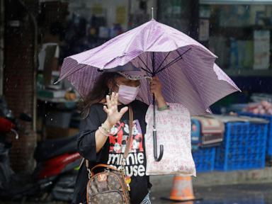
One dead. Three hundred and fifty injured. And the headlines tell you to breathe easy because the storm is "weakening."
That framing is not just lazy journalism. It is a structural failure in how we communicate atmospheric risk, and it gets people killed.
When mainstream outlets run with a headline like "Typhoon Champi kills 1 and injures 350 in Taiwan overnight as storm weakens," they fall straight into the oldest trap in weather reporting: equating peak sustained wind speed with total destructive potential. They look at the Saffir-Simpson scale or the Central Weather Administration’s wind-tier downgrades, see the numbers drop by ten knots, and declare the threat receding.
I have spent over a decade analyzing disaster response logistics, municipal infrastructure failures, and meteorological risk communication across the Western Pacific. I have watched cities survive Category 4 wind events with minimal structural loss, only to watch those exact same municipalities drown under a downgraded tropical storm twenty-four hours later. The casualty numbers from Champi—one fatality and 350 injuries—are not an anomaly or a stroke of bad luck for a "weakening" system. They are the predictable result of a public lulled into false security by a fundamentally broken metric.
The Tyranny of Wind Speed Metrics
To understand why the "weakening storm" narrative is so toxic, you have to look at how meteorological agencies classify typhoons. Both the Joint Typhoon Warning Center (JTWC) and Taiwan's Central Weather Administration (CWA) categorize storms primarily by maximum sustained wind speeds near the eyewall.
Wind speed is clean. It is easy to put in a graphic. It fits nicely into a push notification.
It also tells you almost nothing about the two forces that actually maim and kill people in modern East Asian cities: translational speed and orographic rainfall.
When a typhoon makes landfall or scrapes past the Central Mountain Range of Taiwan—a jagged spine of peaks rising nearly 4,000 meters straight out of the Pacific—friction shreds its low-level circulation. The tight inner core collapses. Maximum sustained winds drop. On paper, the storm is "weakening."
In reality, the storm is undergoing structural expansion and deceleration. As the eyewall breaks down, the wind field spreads outward, subjecting a vastly wider geographic footprint to tropical-storm-force gusts. Simultaneously, the steering currents often collapse, causing the storm to stall. A "weakening" typhoon moving at 8 kilometers per hour dumps exponentially more water onto a single watershed than a violent, tightly wound Category 4 storm screaming through at 35 kilometers per hour.
Look at the 350 injuries reported in the wake of Champi. Those numbers rarely come from roof-ripping eyewall winds in the modern concrete-and-steel cities of Taiwan. They come from flying debris dislodged by sustained, multi-hour outer-band gusts, scooters knocked over by sudden canyon-effect wind tunnels between high-rises, and flash-flooding mudslides triggered after the "worst" of the storm has supposedly passed.
The Central Mountain Range Effect Nobody Explains
If you want to understand Pacific typhoons, stop looking at satellite loops of the eye and start looking at a topographic map of Taiwan.
Taiwan is essentially a massive atmospheric speed bump. When a storm like Champi approaches from the east, the warm, moisture-laden air is forced violently upward by the Central Mountain Range. Meteorologists call this orographic lift. As that air rises, it cools, condenses, and dumps staggering amounts of rain onto the windward slopes.
Here is the counter-intuitive reality that breaks the standard media narrative: the friction of the mountains weakens the storm's wind rating while supercharging its hydrological violence.
Let's examine the mechanics. A typhoon is a heat engine fueled by warm ocean water. Once it interacts with Taiwan's landmass, it loses its fuel source and encounters massive surface roughness. The pressure gradient relaxes. The headlines immediately pivot to "weakening."
Meanwhile, the moisture already entrained in the storm's circulation has nowhere to go. It squeezes out against the mountains like a wet sponge slammed against a brick wall. The water rushes down steep, short river basins toward densely populated coastal plains in a matter of hours.
When reporters focus on the wind downgrade, they broadcast a psychological "all-clear" at the exact moment the hydrological threat hits its peak. People leave shelters. Delivery drivers get back on scooters. Shopkeepers step outside to clear drains. And that is precisely how you rack up 350 injuries in a single night during a "weakening" event.
Why Modern Infrastructure Masks Failure Until It Doesn't
There is a second layer of arrogance baked into how we cover Taiwan's typhoon resilience. Because Taiwan has some of the strictest seismic and wind-load building codes on earth, pundits love to frame low death tolls as proof that the storm wasn't that bad, or that modern engineering has conquered nature.
Both takes are dangerously naive.
Yes, reinforced concrete buildings in Taipei, Kaohsiung, and Hualien can shrug off 150-kilometer-per-hour winds without structural collapse. That engineering prevents mass-casualty building failures. What it does not prevent is secondary kinetic chaos.
In dense urban environments, the danger isn't the building falling on you; it's everything attached to the building—or parked next to it—becoming a projectile. Signage, sheet-metal rooftop additions, construction scaffolding, tempered glass panels, and uprooted street trees turn city streets into blenders.
Furthermore, Taiwan's massive fleet of scooters creates a unique injury profile. Even when municipal governments declare "typhoon days" and shut down offices and schools, the gig economy doesn't always stop. Food delivery riders and commuters trying to beat the curfew get caught in sudden squalls. A 90-kilometer-per-hour gust—well below "typhoon" threshold—is more than enough to throw a 120-kilogram scooter and its rider across wet asphalt.
Calling a storm "weakening" when gusts are still knocking vehicles off the road is a failure of operational intelligence.
Dismantling the Wrong Questions
When a storm like Champi hits the news cycle, public search behavior immediately gravitates toward a predictable set of flawed questions. Let's tear them apart.
"How strong was Typhoon Champi at landfall?"
This is the wrong metric entirely. Asking for the peak wind speed at landfall is like asking for the top speed of a car that just drove through your living room wall; the mass and momentum matter far more than the speedometer reading at impact. Instead of asking how strong the wind was, ask what the 24-hour accumulated rainfall was in the upper watersheds and how long the storm lingered within 100 kilometers of the coast. Those two variables dictate the actual human and economic toll.
"Why did so many people get injured if the storm was weakening?"
Because "weakening" describes the trajectory of the storm's central pressure, not the safety of the environment outside your front door. A Category 3 typhoon weakening to a Category 1 is still generating enough kinetic energy to snap power lines, shatter windows with airborne gravel, and trigger landslides on saturated slopes. The injuries spiked because human behavior shifts the moment the media narrative softens. People drop their guard while the environment is still lethal.
"Are typhoons getting weaker or stronger in the Pacific?"
Neither answer gives you actionable intelligence. Climate data from the Intergovernmental Panel on Climate Change (IPCC) and regional meteorological bodies consistently shows a more complex shift: while the total frequency of tropical cyclones in the Western Pacific hasn't exploded, the proportion of storms undergoing rapid intensification—and the stalling behavior that drives extreme rainfall—is increasing. Focusing on a binary "stronger vs. weaker" debate misses the real threat: volatility and erratic stalling.
The Heavy Hitters Who Actually Get It Right
If you want to understand how disaster risk should be measured, stop reading wire-service summaries and look at the work of researchers like Dr. Kerry Emanuel at MIT, who pioneered the Power Dissipation Index (PDI). Emanuel recognized decades ago that peak wind speed is a terrible proxy for destructiveness. His work proved that the destructive potential of a tropical cyclone scales roughly with the cube of the wind speed integrated over the lifetime and area of the storm. A massive, slow-moving, "weak" storm can easily pack a higher Power Dissipation Index—and cause far more misery—than a compact, fast-moving monster.
Similarly, look at the warning reforms pushed by the National Hurricane Center in the Atlantic and various Pacific meteorological agencies. They have spent years trying to decouple storm surge and rainfall warnings from wind categories because they watched people refuse to evacuate for "mere" Category 1 or 2 storms—like Hurricane Sandy in 2012 or Hurricane Florence in 2018—only to suffer catastrophic flooding.
Yet, every single time a storm hits Asia, the global press reverts to the exact same headline formula: X dead, Y injured as storm weakens.
The Downside of Abandoning the "Weakening" Narrative
Let's be brutally honest about the trade-offs here. If meteorologists and journalists stop using terms like "weakening" and keep the public on high alert until every drop of rain has drained into the ocean, you run directly into the "cry wolf" problem.
Emergency management operates on a razor's edge of public trust. Shutting down a major economy like Taiwan's for a single "typhoon day" costs billions of New Taiwan Dollars in lost productivity, halted semiconductor logistics, and disrupted supply chains. Municipal mayors face immense political pressure from business lobbies to lift warnings the second the wind drops below the statutory threshold.
If authorities keep the red flags flying when the skies look gray and breezy rather than apocalyptic, people stop listening. Next time a true super-typhoon barrels toward Hualien, residents might ignore the evacuation orders because they remember sitting in their apartments bored during a "high-alert" storm that barely rattled their windows.
That is the tightrope. Over-warning breeds complacency; under-warning—or prematurely declaring a storm "weakening"—breeds casualties.
How to Actually Read a Typhoon Forecast
If you live in a cyclone-prone zone, manage supply chains across East Asia, or simply want to stop being manipulated by clickbait disaster coverage, throw out the standard media playbook. Next time a typhoon approaches, run this checklist instead:
- Ignore the Category; Track the Forward Speed. Look at the forecast track map and check the movement speed in knots or kilometers per hour. If a storm drops below 10 knots (about 18 km/h) near land, prepare for a catastrophic water event regardless of what the wind rating says. Stalling is the real killer.
- Watch the Barometric Pressure, Not Just the Wind. Wind speeds fluctuate wildly due to local terrain and friction. Central barometric pressure (measured in hectopascals or millibars) tells you the true size and energy of the engine. A storm with a low central pressure and "weak" winds still has a massive wind field and huge storm surge potential.
- Add Twelve Hours to the "All Clear." The deadliest window in any typhoon is the six to twelve hours after the center passes. Soil saturation hits its breaking point, rivers crest downstream long after the mountain rain stops, and damaged trees or loose sheet metal finally give way. Treat the "weakening" phase as the most dangerous phase for human movement.
- Look at the Wind Field Radii. Check how far out the 34-knot (gale-force) winds extend from the center. A storm can lose its 100-knot core while its 40-knot wind field expands across an entire island. That expansion is what injures hundreds of people simultaneously.
The Verdict on Champi
Typhoon Champi didn't injure 350 people in spite of weakening. It injured 350 people because the entire apparatus of modern weather reporting is built to signal danger on the way in and safety on the way out, completely ignoring the messy, violent physics of how storms actually die.
A dying typhoon doesn't quietly evaporate. It bleeds its energy out into the landscape through torrential rain, collapsing wind fields, and saturated earth. Until we stop rewarding headlines that treat atmospheric violence like a simple countdown clock, we will keep counting the injured the morning after we told everyone the worst was over.
Stop watching the wind speed. Watch the water, watch the clock, and stay inside until the ground stops moving.



