You do not hear the catastrophe. You see it, but the sound arrives late, rolling across the gray water of the fjord like heavy artillery.
By the time the crack of a fracturing ice cliff hits your eardrums, the house-sized block of black-blue ice has already plunged into the sea. It displaces thousands of tons of water, creating a localized tidal wave that churns through the narrow inlet. For decades, this violence has kept us at bay. We want to understand how the world is changing, but the borderlands of Greenland—where the massive ice sheets meet the warming Atlantic Ocean—are a dead zone for human observation. Stand too close on a boat, and a collapsing wall of ice will crush you. Fly too close in a helicopter, and the erratic, freezing downdrafts will swat you from the sky.
We cannot model what we cannot observe. That is the haunting truth that has plagued climate science for a generation. Our computer simulations try to predict how fast the planet will warm and how high the seas will rise, but at the most critical front lines, the data goes dark. We have been forcing global policies to rely on guesswork at the very boundary where the future is being decided.
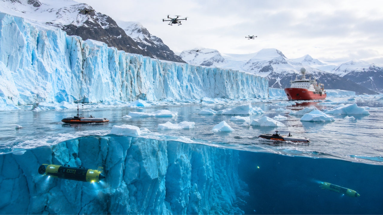
But this summer, the Royal Research Ship Sir David Attenborough is sitting in the freezing waters off Kangerlussuaq in southeast Greenland, carrying a strange cargo. It is an uncrewed squadron. A fleet of autonomous machines, built to go where flesh and bone cannot survive, is moving into the fjords. Scientists once called this mission impossible. Now, it is simply a necessity.
The Mechanics of the Blind Spot
Consider what happens next when an ocean warms. It does not just melt the ice from above under the summer sun. The real destruction happens out of sight, deep beneath the surface, where warm, salty Atlantic currents eat away at the submerged roots of the glaciers.
This process creates turbulent upwelling plumes—underwater rivers of freshwater that rush upward against the ice face, dragging more warm ocean water into the cycle. It is a feedback loop that accelerates ice loss six times faster than what we witnessed thirty years ago. Yet, our current global climate models treat these massive glacier fronts as static, motionless blocks on a spreadsheet. They miss the complex dance between ocean melting and iceberg calving because nobody has ever been close enough to measure the physics of it in real time.
The GIANT project—Greenland Ice sheet to AtlaNtic Tipping points from ice loss—is a five-year international effort designed to permanently erase this blind spot. Instead of risking human lives against the unpredictable ice cliffs, researchers are handing the controls over to a highly specialized robotic army.
The Foot Soldiers of the Fjord
The strategy relies on a symphony of diverse, autonomous designs acting in unison.
High above the fracturing ice, rugged aerial drones fight the bitter polar winds. They fly within meters of the towering vertical ice faces, using high-resolution cameras to map the microscopic lines of stress. It is a forensic investigation of a collapse. They are looking for the exact structural failures that precede a major calving event.
On the surface of the water, a robotic boat dances between floating icebergs. It uses multibeam sonar to send sound waves piercing through the murky, sediment-heavy water, painting a continuous three-dimensional portrait of the hidden underwater ice walls.
Below the surface is where the true ghosts of the fleet operate. Autonomous underwater vehicles, some just a few meters long, dive hundreds of meters into the freezing dark. Among them is Boaty McBoatface, the famous yellow submarine exploring beneath the floating ice shelves to map their changing geometry. These machines measure temperature, salinity, and current speeds, capturing the exact moment the ocean transfers its heat to the frozen continent.
Even the ice itself is being wired. Helicopters drop GPS-equipped javelins that plunge from the air and embed themselves deep into the moving glacier surface, continuously transmitting data on how fast the ice is sliding toward the sea. Far below the waterline, tiny, screw-in sensors attach themselves directly to the underwater ice cliffs. As the glacier melts around them, these intelligent sensors automatically adjust their grip, burrowing deeper into the ice while recording turbulence and melt rates in real time.
The Missing Numbers
This is not a tech showcase. The stakes are deeply practical. The freshwater pouring out of Greenland does not just raise sea levels; it threatens to freshen the North Atlantic enough to disrupt the massive ocean currents that regulate weather patterns across Europe and North America. If those currents slow or shut down, the climatic shift will be sudden, drastic, and irreversible.
By feeding this torrent of new, real-time data into advanced simulation tools, researchers are building a prototype early warning system. Artificial intelligence algorithms are already analyzing the gaps in our current maps, identifying the precise geographic blind spots where the robots should be deployed next.
We are finally moving past the era of satellite estimation. We are learning to watch the system from the inside, observing phenomena down to the millimeter—like tracking the tiny air bubbles popping out of the melting ice, a detail that changes how heat moves from water to frozen capital.
The ship will spend the coming weeks in the southeastern fjords before moving the campaign to the massive Petermann Glacier in the northwest next year. The robots will keep diving, screwing into the ice, and mapping the fractures in the dark. They do not feel the bitter cold, and they do not fear the thunder of the collapsing cliffs. They are simply collecting the numbers we need to see what is coming around the corner before the ice shatters completely.
_(cropped).jpg/440px-Rob_O'Neill_(40543587961)_(cropped).jpg)